
Caribbean Underwater Pyramids
 One of the most intriguing tales of the discovery of ruins of a lost civilization is the story of Dr. Ray Brown. In 1970, while diving near the Bari Islands in the Bahamas, Dr. Brown claimed to have come across a pyramid "shining like a mirror" that he estimated was 120 feet tall, although he could see only the top 90 feet. The pyramid had a colored capstone and was surrounded by the ruins of other buildings. Swimming into a chamber he found a crystal held by two metallic hands. Over the crystal hung a brass rod from the center of the ceiling, at the end of which was a red multifaceted gem of some kind. Brown said he took the crystal, which allegedly has strange, mystical powers.
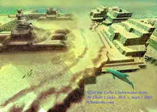
 A 'lost city', that could turn out to be the fabled city of Atlantis, has been located by a Canadian scientific research team. In a press release dated Havana, 14 May 2001 Reuters of London informed the world that Soviet-born ocean engineer Paulina Zelitsky, the president of Canadian-based company Advanced Digital Communications, had detected 'a sunken city' in deep waters off the west coast of Cuba, the largest island of the Caribbean. Satellite-integrated ocean bottom positioning systems, echo sounders and high precision side-scan double-frequency sonar have detected the presence of what are being described as 'shapes' that 'resemble pyramids, roads and buildings'. Their regularity seems consistent with the idea that they represent an 'urban development' composed of 'symmetrical architecture'. Reuters reported that the deep-sea city is located on a huge land plateau lying in around 2,200 feet (700 metres) of water. Furthermore, that in Paulina's opinion the complex belongs to 'the pre-classic period' of Central American history, and was populated by 'an advanced civilization similar to the early Teotihuacán culture of Yucatán'. 'It is stunning,' she said during an interview with the Reuters representative at her office at Tarara, on the coast east of Havana. 'What we see in our high-resolution sonar images are limitless, rolling, white sand plains and, in the middle of this beautiful white sand, there are clear man-made large-size architectural designs. It looks like when you fly over an urban development in a plane and you see highways, tunnels and buildings. 'We don't know what it is, and we don't have the videotaped evidence of this yet, but we do not believe that nature is capable of producing planned symmetrical architecture, unless it is a miracle,' she added. Paulina is cautious about what lies beneath the glistening blue waters of the Yucatán Channel, admitting
 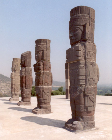 only that she is 'excited but reluctant to speculate until a joint investigation with the Cuban Academy of Sciences and the National Geographic Society takes place early this summer.' The discoveries were made last summer during deep-sea surveys made by Paulina and a trained scientific research team aboard the Cuban research vessel Ulises. Sonar images revealed 'an extensive series of structures' over a several-mile area in darker and lighter shades. The site is close to the edge of the underwater geological feature known as the Cuban shelf, which falls off sharply in a series of shelves which drop down to several thousand metres, and it is on one of these shelves, in around 600-700 metres of water, that the structures are to be found. The mass of rectilinear features are said to be located in the proximity of an 'extinct volcano, geological faults and a river bed'. This last fact alone shows that the land shelf, which rises to a height of around 40 metres, was once above water. 'Whenever you find a volcano, there is often a settlement associated with it,' Paul Weinzweig, Paulina's husband and a director of ADC, observed. 'I don't know the exact relationship, but it is in the same vicinity as the volcano, the fault lines and the river. They're quite close to one another.' On the matter of whether the sonar imagery really does show 'pyramids, roads and buildings', Paul stated: 'We had been looking at the images for some months, and keep a picture on the wall showing
  pyramids in the Yucatán, and let's just say they kept reminding us of these structures. They really do look like an urban development.' As to whether the light and dark areas of the sonar imagery appear to be three-dimensional features or not, he answered: 'There's a lot of symmetry, apart from actual shapes, and some suggestion of structure. Some American geologists have looked at them and said that the darker shadings are suggestive of metal roofing.' In order to explore the site more closely, ADC are currently planning to send down remote robot video cameras and a one-man submersible. We therefore look forward to further news of these discoveries in the coming months.
The Search for Sunken Vessels
ADC's intentions had never been to search for sunken cities. Their scientific operation to survey the deep waters off the Cuban coastline forms part of a joint venture set up between the Canadian company and the Cuban government, in particular its state partner Geomar. One of
 their principal aims is the location of the billions of dollars of bullion and lost treasure disgorged from sunken ships since the time of the Conquest. As Paul said: 'Cuba has the richest galleon cemetery in the world.' Over the past 500 years it is estimated that hundreds, if not thousands, of vessels must have been lost in Cuban waters due poor navigation, piracy on the high seas and the violent Caribbean storms that plague the region on a frighteningly regular basis. Visa Gold, a Toronto-based low-tech company which operates out of Havana's Marina Hemingway, claims already to have found some 7,000 objects from sunken vessels. They include jewellery, diamonds and pistols, said to have come from a brigantine called Palemon, lost off Cuba's northern coast in 1839. Visa Gold's next target is the Atocha y San Jose, a Spanish vessel. It sank in Havana Bay in
  January 1642 after fleeing storms at sea. The renewed interest in treasure salving in Cuban coastal waters comes in the wake of Fidel Castro's government recognising the fact that it does not have the ocean expertise or the inclination to conduct scientific operations of this nature. Its divers, who are considered to be among the best in the world, have been diving off Cuba's coast treasure hunting for decades. Yet Cuba lacks expertise and technology for deep-ocean search and science, which is why they have invited ADC to take up the challenge. Their 80-metre oceanographic reseach vessel, the Ulises, uses high-tech equipment and a highly trained scientific team to survey the ocean bottom up to a depth of several thousand metres. It was their high-skilled sonar software analysts who detected the reported underwater remains in the Yucatán Channel. 'These projects are very important in helping us rescue things from history, which contribute to our national patrimony,' said Eddy Fernandez, vice president of Geomar. 'As you know, we have financing problems. This is a very expensive activity. They give us technology and financing. We provide historical and ocean expertise'.
THE CUBA-ATLANTIS ARGUMENT
The implications of ADC's discoveries off Cuba's western coastline are far reaching and quite extraordinary. In an on-line pole, conducted by the NBC home news service MSNBC, of the 1827 people who had voted by the end of 26 May 2001, no less than 73 percent believed that the find 'could be something big: Next stop, Atlantis'. It means that already NBC are considering the possibility that the sunken city could be linked with Plato's account of the lost city of Atlantis. This is good news for me, as my book GATEWAY TO ATLANTIS, published in 2000, concluded that the most likely location of Plato's sunken empire was Cuba, the first time that this country had ever been proposed in this respect. I pointed out that the evidence contained in Plato's works the TIMAEUS and CRITIAS hinted strongly that his view of Atlantis was based on stories and rumours reaching the ancient world via Phoenician and Carthaginian who were crossing the
 Atlantic prior to his age. Moreover, Plato's description of Atlantis' great plain, said to have been 3000 by 2000 stadia (552 by 368 kilometres) in size, matches very well Cuba's great western plain. Before the rapid rise in sea-level following the end of the last Ice Age this stretched southwards across the Bay of Batabanó to the mysterious Isle of Youth and was originally 540 by 160 kilometres in size. Although I speculated in the book - which has now been published in the USA, Italy, Holland, Germany and Portugal - that the Atlantean city might await discovery beneath the shallow waters of the Bay of Batabanó, news that a sunken city may now have been detected in the Yucatán Channel, between Cuba and the Yucatán peninsular, is exciting news. Incidentally, ADC have plans to explore the Bay of Batabanó during the next year, so it should be interesting to see what if anything they find here.
The Search for the Mother Lode
 In September 1972 American oceanic explorer J. Manson Valentine, flying over the Bahamas in a light aircraft with and his associate Jim Richardson, noticed a mass of rectilinear and curvilinear features in shallow waters on the south-western edge of the former Bahaman landmass (now the Great Bahama Bank). Valentine referred to this mass of possible archaeological features as 'the mother lode'. They faced out across the Old Bahama
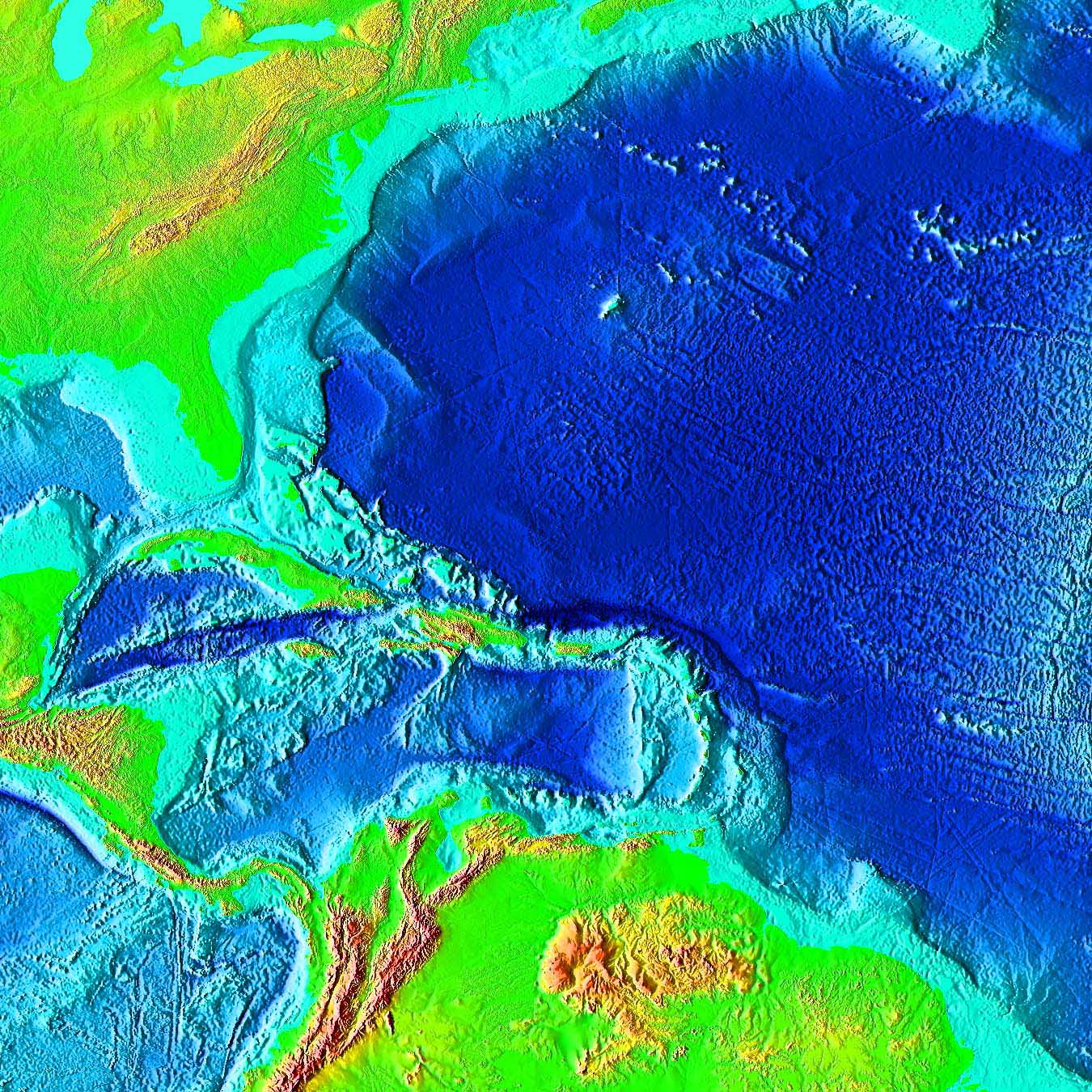 Channel, like some kind of ancient port serving the Cuban mainland. As early as the 1950s light-aircraft pilots reported seeing what they described as underwater 'stonework' which was 'well within Cuban waters'. Similar sightings 'north of Cuba' of an alleged 'submerged building complex covering over ten acres' might even have convinced the Cuban government that a veritable city awaited discovery in its vigorously defended waters. There are, for instance, unconfirmed reports that this 'building complex' was explored with the assistance of Soviet submarines based in Cuba during the 1960s. Strange then that these recent discoveries of a sunken city in Cuban waters are being conducted by a Russian-born Canadian oceanographer. Among those who felt they had glimpsed the remains of a lost citadel in Cuban waters was Leicester Hemingway, brother of the writer Ernest Hemingway. During a flight into the country, Leicester noticed, beyond its northern coast, 'an expanse of stone ruins, several acres in area and apparently white, as if they were marble'. The exact location of these underwater features remains unclear. Only time will tell whether the discoveries made by Paulina Zelitsky and ADC do constitute firm evidence of Plato's Atlantis, for if they do then it will fix, once and for all, its geographical location in the Bahamas and Caribbean, and not anywhere else in the world. However, the location of a
  lost city on a huge land plateau lying at a depth of around 600-700 metres poses new problems for the Atlantis debate. Plato wrote that his Atlantic island empire was destroyed by 'earthquakes and floods' in 'one terrible day and night', post-8570 BC in the TIMAEUS and around 9421 BC in the CRITIAS. This time-frame corresponds with the cessation of the last Ice Age, when we know that the sea-levels began to rise fairly rapidly as the ice fields which had covered vast areas of North America and Europe for tens of thousands of years began to disappear. In GATEWAY TO ATLANTIS I proposed that the mechanism behind Atlantis' destruction was a comet impact which devastated the eastern Atlantic coast of America, causing literally 500,000 elliptical craters, known today as the Carolina Bays, sometime around 8500 BC (+/- 500 years). Fragments of the comet falling in the Western Atlantic basin, north of the Bahamas, would have created tsunami tidal-waves perhaps hundreds of metres high. These would have drowned, temporarily at least, large parts of the Bahamas and Caribbean, as well as many low-lying regions of the eastern United States. Myths and legends told by the indigenous peoples of the Bahaman and Caribbean archipelagos, when the Spanish first reached the New World, spoke of just such a cataclysm. They said that the waters suddenly rushed in and drowned the great landmass, breaking it up into the individual islands seen today. Although a fragmentation of the former landmasses of the Bahamas and Caribbean in the manner indicated could not have been caused by tsunamis alone, the gradual rise in the sea-level which followed this cataclysmic event would have drowned, more permanently this time, all low-lying regions, creating the archipelagos we see today. Yet in the thousands of years which it took for the ice fields to melt in
  full, the sea-level rose only 300 metres (some estimates place it as much as 400 metres). If the 'city' does lie in 600-700 metres of water, we will need to propose a suitable geological mechanism in order to justify its submergence to this depth post 9000 BC. Either that, or we will have to define a geological time-frame in which the land plateau, with its volcano, fault lines and river was above sea-level. Paulina's statement that the 'city' might belong to 'the pre-classic period' of Mesoamerican history, and was populated 'by an advanced civilisation similar to the early Teotihuacán culture of Yucatán', is very difficult to equate with the discovery. The Teotihuacán culture, which thrived in Central Mexico from around 400 BC through until around AD 500, remains an enigma to archaeologists. Its origin is unclear. What we do know is that legends once told by the Totonac peoples of eastern Mexico spoke of the founders of its sacred city of Teotihuacán, with its mighty Pyramids of the Sun and Moon, as having arrived on the Gulf coast from an island homeland which lay beyond the sea. Here was to
  be found Chicomoztoc, the Seven Caves, where the first humans emerged out of the darkness at the beginning of time. For many reasons, not least of all the appearance of sea-shells of a purely Caribbean nature carved on the walls of the Temple of Quetzalcoatl at Teotihuacán, the Teotihuacán culture saw their ancestral homeland as connected in some way with the Caribbean. Moreover, in GATEWAY TO ATLANTIS I identified the original Seven Caves complex as the Punta del Esté caves on Cuba's Isle of Youth, one of which, Ceuva # 1, has been described as a veritable Sistine Chapel of the prehistoric world. Many thousands of years ago unknown artists adorned its walls and ceilings with abstract petroglyphs of a blatantly celestial nature. Yet even so, any sunken city lying off the northern coast of Cuba, in 600-700 metres of water, must antedate the Teotihuacán culture by many thousands of years. Curiously, Pauline Zelitsky visited Ceuva # 1 at the Punta del Esté complex
  during the summer of 2000, shortly before she made her dramatic discovery of the underwater 'city'. There is something magical about this place. It assaults the senses and inspires thoughts regarding the origins of Cuba's indigenous peoples and their apparent knowledge of the cataclysm which devastated the region so many thousands of years ago. If Paulina Zelitsky and her oceanographic colleagues are right in their belief that 'pyramids, roads and buildings' do lie off Cuba's western coastline, then it is clear that the prehistory of the Caribbean, and its influence on the rise of Mesoamerican civilisation, will have to be revised dramatically. Moreover, it could well be that at long last the mystery of Atlantis, mankind's greatest historical enigma, is about to unfold in a most spectacular fashion. Sources: 'Looking for lost riches in Cuba's seas: Underwater surveyors say they may have found sunken city', Reuters report dated Havana, 14 May, 2001, Collins, Andrew, GATEWAY TO ATLANTIS, Headline, London, 2000; Carroll & Graf, USA, 2000.
Egyptian Treasures in the Grand Canyon
 The April 5, 1909 edition of the Arizona Gazette featured an article entitled "Explorations in Grand Canyon: Remarkable finds indicate ancient people migrated from Orient." According to the article, the expedition was financed by the Smithsonian Institute and discovered artifacts that would, if verified, stand conventional history on its ear. Inside a cavern "hewn in solid rock by human hands" were found tablets bearing hieroglyphics, copper weapons, statues of Egyptian deities and mummies. Although highly intriguing, the truth of this story is in doubt simply because the site has never been re-found. The Smithsonian disavows all knowledge of the discovery, and several expeditions searching for the cavern have come up empty-handed. Was the article just a hoax? "While it cannot be discounted that the entire story is an elaborate newspaper hoax," writes researcher/explorer David Hatcher Childress, "the fact that it was on the front page, named the prestigious Smithsonian Institution, and gave a highly detailed story that went on for several pages, lends a great deal to its credibility. It is hard to believe such a story could have come out of thin air."
On April 5th, 1909, there appeared a front page story in the Arizona Gazette. It told of an archeological expedition in the heart of the Grand Canyon funded by the Smithsonian Institute. (a full transcription of the article can be found at: www.keelynet.com/unclass/canyon.txt) It is a rich story of finding a labyrinth of man-made tunnel systems high above the Colorado River, a virtual citadel filled with ancient artifacts, hieroglyphs, armor, statues of deities and even mummies. Anyone contacting the Smithsonian Institute will receive a polite "no records found" reply to an inquiry about their supposed role in the Grand Canyon.
 The following narration shows how I came to be convinced of an exact location in the Grand Canyon that is a key to this story (regardless of whether the newspaper article is a hoax or not), and contains mathematical proof. This story also reveals an ancient cartographic code that led me to this conclusion, and the meaningful coincidences that unfolded as I pursued this mystery. The location is known as "Isis Temple" and is paramount in a well kept secret that is just now being uncovered in ways far richer and more important than material wealth. The cherished gem of Arizona, the Grand Canyon, one of the seven natural wonders of the world, contains a legacy and a link to a history known only by a few; suppressed not only by greed and politics, but by a forgotten code hidden right beneath our very feet. It is all beginning to come to light now.
I first came across the information about the newspaper article in 1998 via the www. To satisfy my curiosity, I went to the Phoenix Public Library, found the article on microfilm and made a few photo copies of it. I didn't give it too much thought at the time, other than mentioning it from
 time to time to people who attend free speaking engagements and classes I offer. As a 30 year independent researcher in the field of sacred geometry, (sometimes known also as hyper-dimensional geometry, living geometry, and alchemical geometry) and other related subjects, I found the topic relating to Egypt synchronistic, since a lot of my studies revolved around the ancient schools of thought and geometry of sacred sites and temples of Egypt. Like others, I thought it was rather odd, if indeed the article was not a hoax, that evidence of ancient Egyptians would be found in Arizona, of all places!..... After all, the Egyptians did not explore the Americas, everyone knew that, and it was not taught in any school. We thought this also of the ancient Romans, until ancient Roman headgear, armor, swords, coins and other artifacts were found just North of Tucson, not far from Interstate 10 !
Now that the subject has come up about suppressed information, if indeed that is what it is, there is a well researched book of 914 pages by Michael Cremo and Richard Thompson titled Forbidden Archeology, which can open anyone's' third eye to a history of mankind that has never been taught, except in those 'mystery schools' so well cloaked in myth, secrecy and ridicule. Some good information can be found by searching the archives of www.dailygrail.com and also www.mcremo.com.
Then in October of 2000 I came upon a another web site that had lots of information and photos of Egyptian hieroglyphs found a hundred years ago in Australia ! The hieroglyphs were on the stone wall next to a cave entrance, and told of ancient Egyptian explorers getting lost and stranded, left to die in Australia. (see: www.ozemail.com.au/~classblu/egypt/egypt.htm)
At around the same time I happened to read in a book titled Ancient Secret of The Flower of Life, Vol. II, page 302, the story of two backpackers who ventured into the Grand Canyon. What they claimed to have found first, while on their way to a location known as Isis Temple, (see photo at: www.hitthetrail.com/mikespages/isis.htm) was a rather large pyramid made from the native rock. Once at Isis Temple, at an elevation of about 800 feet, they claimed to have seen several cave entrances, just as reported in the newspaper article. They also noticed that they all seemed to be sealed shut or destroyed, as if to keep everyone out. (the question here arises, why deliberate sealing of caves in such a remote, hard to access, area?) Because they were also expert rock climbers, they climbed the 800 feet to the most promising looking cave entrance. Upon reaching the entrance they discovered that it too had been sealed off several feet in with native rock. They did notice, however, that the entrance seemed to be man made and that there was a 6 foot circular pattern clearly hewn into the ceiling. This story was told to the author of the book, and from the context of the material presented in the book and from the nature of the author's character, of whom I am familiar, I could not for the life of me imagine why such a story would be fabricated and told to him unless it were absolutely true.
And yet, Isis Temple (which can be seen from the South Rim visitors areas) is at least 40 miles from the location given in the newspaper article. So, if the newspaper article was not a hoax, and Isis Temple was the real location, the other location could have been misinformation to keep people away. Then again, if the newspaper article was a hoax, what then had the two backpackers stumbled upon ? And why were extremely remote cave entrances sealed ?
A question arises here also: why are there so many geographical locations in the Grand Canyon named after Egyptian and Hindu deities?
Then, approximately two weeks later, on October 13, channel 10 (one of our local t.v. stations), did a short segment on their weekly t.v. news magazine show about the 1909 article and some local people actively looking for it out at the Canyon. I contacted the producer of the segment and left my name and phone number, telling him to give it to a couple of the people he had interviewed, as I could supply them with this information regarding Isis Temple. At the very least they could go with good telescopes and look for cave entrances from the Rim to confirm their existence. Simple.
As of yet no one has called me back.
I plan to check the condition and strength of my old telescope and go there myself soon. A severely damaged disc in my back prevents me from an actual backpacking trip to Isis Temple, as the trip is extremely arduous and requires at least six days of backpacking in some of the most challenging terrain on the planet.
The next thing I did was call the "Back Country" information line (520-638-7875) at the Grand Canyon, where permits are bought for backpacking and extended hikes, both on and off trails. The lady was very talkative, polite and helpful. She even suggested two books I should read on possible routes to Isis Temple since there are no trails to it. Then I casually brought up the subject of possibly exploring caves I had heard about at Isis Temple and asked her if she could confirm their existence. Her reply was a simple, but emphatic "NO". Then a long pause. Then very curtly she said the Park Dept. was about to engage in a Canyon-wide research project into the bat population and habitation, to make sure they were not being endangered. Everyone was to stay out of caves she said. That ended our conversation. Interesting, but not conclusive.
 In the meantime, this whole thing was getting under my curious skin a bit. I decided to approach the subject a little differently. I was going to see if there was a geometrical connection between Isis Temple and the Great Pyramid of Giza. Why the Great Pyramid? From my knowledge of sacred geometry I knew it to be a central figure in a planetary grid system. As a former, avid backpacker myself, and having some knowledge of cartology, it took me no time to get the exact longitude and latitude of the center of Isis Temple. I then began searching on the www for the exact coordinates of the center of the Great Pyramid in Egypt.
That's when things started to turn REALLY curious and informative.
My web search brought me more than I could have hoped for. It led me to the work of a man named Carl Munck. (see: www.pyramidmatrix.com) Over ten years ago he had started doing a similar thing that I was attempting, but he had started at Stonehenge, trying to find a longitude/latitude relationship with the Great Pyramid. His continued work led to the discovery of what is now called Archeocartology, and the key to the system is using the Great Pyramid as Prime Meridian rather than Greenwich . What he had done was eventually find a whole code system that the ancient's knew about and had used in determining where to place sacred temples, and sacred sites. It is simply known as THE CODE, or Code of the Ancients. He has several books out on the subject, a newsletter and several videos.
From THE CODE we get factual, mathematically provable evidence that all ancient sites, megaliths, temples, stone circles, effigies and certain natural formations and vortexes across the entire face of the globe are very precisely located on a global coordinate system in relation to the Great Pyramid. ( I know, this is hard to believe, but read on) Not only that, but an ancient numerology system known as Gematria (used by Egyptians, Greeks, Persians, Babylonians, Romans and others of the ancient world) is used in the manipulation of the numbers that relates the numbers to other key locations, mathematical constants such as Pi and the radian, and the positions of the sites themselves given in the geometry of their physical construction.
GEMATRIA and THE CODE can be considered to be "whole brain" methodologies. In other words, both bi-lateral functions of the brain must be employed to reach applicable and functional results. Or, the left, rational/verbal/lineal, side of the brain and the right, intuitive/imaginative/non-lineal, side must work together, in much the same way as when viewing stereo-gram images, sometimes known as 'Magic Eye' pictures also. (Those pictures that were popular a few years back that looked like just a mass of colored dots when first seen, but after gazing in a particular manner for a while a complete 3-D picture or scene 'popped' out to your vision. Usually children and young adults have an easier time seeing the pictures because they are not yet as completely absorbed with just left brain, rational, thinking habits, and their right brain, creative, side is more flexible.)
 THE CODE of Carl Munck dovetails perfectly with the planetary grid system and the related Platonic Grid Lines found by Ivan Sanderson, Bruce Cathie, William Becker and Bethi Hagens. The world grid system (www.ascension2000.com/convergence/9918.html) is commonly known as the Unified Vector Geometry 120 Polyhedron. Interestingly enough, THE CODE also is applicable to the Planet Mars, when the North/South Prime Meridian passes exactly through nose of the famous "Face" in the Cydonia area and the "D & M Pyramid".
Still with me? I hope so, because this is all mathematically verified.
Aside from the obvious question that this arouses regarding how such ancient people could have knowledge of such a system and implement if for thousands of years, (which, because there is no short answer for that question, I will not address here) there is also the question of how such feats were accomplished with so much accuracy without the aid of modern technology, like our Global Positioning System (GPS) which uses satellite telemetry and computer accuracy to achieve what the ancients accomplished with ... what ?
When this sort of question arises in my talks and classes, I pull out an object to demonstrate the dynamics of geometry and simplicity. It is a solid object with no moving parts or batteries, and it fits in your hand. It has a unique property about it that no mind on Earth, that I am aware of, can explain. (and it has been under heavy scrutiny by some of the best minds of engineering and physics at University levels) It absolutely defies one of the basic laws of physics and motion. (and this is not my imagination! Just ask my wife.)
People usually gasp and don't believe their eyes when they first see what this object does. And it does this without high technology. I show it to them over and over again, and let them try it for themselves, and it always works. And the key to the object is in its proportions, its shape, its geometry...the mathematics involved. Plain and simple. (Ask me and I'll show it to anyone at any time, anyplace. It is not my invention and it has been around for almost 30 years, yet few people know of it.)
If you know the key to something, or have the something that employs the key, optional methodologies are available to use. It is obvious the ancients had optional methodologies in finding, plotting and implementing building sites based upon a longitude and latitude not all that dissimilar to our own. It is also obvious from the data that the ancients new exactly where the equator was and employed it.
 Another device that should be mentioned is a survey and navigational tool designed by Crichton Miller, who received a patent on it just recently in the United Kingdom. The device is nothing more than two pieces of straight wood formed into a cross with a pivot point where they meet, a plumb line coming down from the pivot point, and a semi-circular scale (similar to a protractor) attached. It looks very much like a Celtic Cross. It is very accurate and requires no batteries. (see: www.dailygrail.com/ misc/cem130700.html for complete details ) A book about the device is due in the Spring of 2001. It is believed this device, or similar, was used in surveying for the Great Pyramid, and also employed as a navigational tool for ocean-going explorations. And speaking of accuracy, as well as complexity of problem solving capabilities with no complex technology or batteries, think for a minute of the slide rule and the abacus.
Anyway, back to the story here....
Well, now I had the longitude and latitude of the Great Pyramid, and a mathematical system for finding a relationship between Isis Temple and the Great Pyramid. But, I got lazy here. I contacted Michael Lawrence Morton, who I had found through another web site . ( www.greatdreams.com/gem1.htm ) ( also http://hometown.aol/marscode/giza.html) I gave him the coordinates for Isis Temple and let him do the math and find the mathematical correspondences. Since Michael was very familiar with THE CODE, also familiar with all the mathematical constants and numerous other sites and their mathematical connections, and had also discovered and applied THE CODE to the local stars and astronomy (the Archeo-Sky Matrix ), I felt confident in his abilities and expertise.
In his words, Isis Temple is a "...major....major site !!!" This he could safely say with confidence because the numbers related to so many other major sites, including the Great Pyramid, and with numbers typically accurate to complete whole numbers, to within 7 and 8 decimal places, and decimal harmonics from 7 to 8 decimal places !
 The following is a brief synopsis of just some of the mathematical connections to Isis Temple. The search is still ongoing. Statistics relating to certain "dates of occurrences" and the Gematria of a personal nature that were found have been left out. The math proof of the following findings is attached at the end of this narration, with full credit graciously attributed to Carl Munck and especially Michael Lawrence Morton, without whom this search would have come to a dead halt.
Isis Temple is mathematically connected to:
* slope angle of the Great Pyramid * grid point value of the Great Pyramid * derived height of Great Pyramid with capstone included * decimal harmonic of the East longitude of the Sphinx at Giza * decimal harmonic of the West longitude of the Chephren Pyramid at Giza * decimal harmonic of the tangent of arc-distance from Earth's equator to either pole * radius of Moon * ratio of radius of Stonehenge's Sarsen Circle and Radian (deg) * decimal harmonic of generic area of a circle * grid point value of the star Sirius, circa 2000 a.d. * grid point value of the star Regulus, circa 2000 a.d. * East latitude, in arc-min., of the "Face" at Cydonia on Mars
At this point, it doesn't matter if Isis Temple is the location mentioned in the 1909 article. At this point it doesn't matter if the article was a hoax or not. Maybe it doesn't matter if archeological information has been withheld from the public (in this regard I am more inclined to believe it is a matter of information filtration brought about by a social process rather than a conspiracy). Maybe it doesn't matter if there are or are not sealed caves in Isis Temple. But I, for one, continue the search. There is still a vast treasure to behold that makes that which we carry in our pocket quite moot when compared to the big picture.
Archeocartographic findings of ISIS TEMPLE based upon THE CODE of Carl Munck and the ARCHEO-SKY MATRIX Code, mathematics and correlations found by Michael Lawrence Morton.
location of Isis Temple N. of Equator and West of Great Pyramid, Giza: 36 deg 08 min 27 sec N. 143 deg 16 min 14.8 sec W.G.
36 x 8 x 27 = 7776 N. 143 x 16 x 14.8 = 33862.4 W.G.
33862.4 / 7776 = 4.3547325 G.P. (grid point)
4.353957151 (G.P.) = Pi x 1.177245771 x 1.177245771 ( 1.177245771 = ratio of the radius of Stonehenge's Sarsen Circle in British feet and Radian (deg.) .....1.177245771 = 57.29577951 / 48.6693441...also the decimal harmonic in arc-seconds of the West longitude of the Chephren Pyramid at Giza, the East longitude of the Sphinx at Giza, and the tangent of arc-distance, adding to actual statute mileage figure, in statute miles, from Earth's equator to either pole....6214.85528 )
4.353957151 (G.P.) x 248.0502134 = 1080 (248.0502134 = grid point value of Great Pyramid.....1080 = mean radius of Moon in statute miles, and 1080 is also the feminine gematrian number for alchemical fusion where 1080 + 666 = 1746 )
33862.4 (W.G) x 57.29577951 x 57.29577951 = 10.31324031 ( 10.31324031 = decimal harmonic of the square arc degrees of a circle, the generic area of a circle, where Pi x 57.29577951 x 57.29577951 = 10313.24031)
10.31324031 = 4.3539557149 (G.P.) x 2.368705056 ( 2.368705056 = grid point value of the binary star Sirius, circa 2000 a.d. )
270 / 4.353957149 (G.P.) = ( Pi x 19.7392088) ( 270 is average number of human gestation days...divided by Isis's Temple grid point value of 4.353957149 = the grid point value of the binary star Regulus, star in the heart of the Lion constellation Leo, or 19.7392088 x Pi. Also, 270 = 9 x 30, and 30 is the grid point value of the intersection of 7th Ave. and Indian School Rd. in Phoenix, Arizona, which is where, on March 13, 1997, 8:30 p.m., the "Phoenix UFO" was witnessed to hover for 4 minutes. March 13, 1997 is 5764 days before December 21, 2012 a.d., end of the Mayan calendar. 5764.166073 is the derived original full height, including capstone, of the Great Pyramid in regular British inches. )
30 / 4.353957149 (G.P.) = 6.890283706 (6.890283706 = arc-minutes East of Mars Prime Meridian = latitude of "The Face" at Cydonia. ) (see also: http://farshores.topcities.com/farshores/mlmindex.htm for all of the above)